Animations Show Extent of Marcellus Shale Development
PennState Cooperative Extension
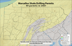
 The pace and extent of Marcellus Shale development across Pennsylvania can be “seen” in animated maps produced by the Penn State Marcellus Center for Outreach and Research.
Based on data from the Pennsylvania Department of Environmental Protection (DEP), the animations show both the number of drilling permits issued for the Marcellus Shale and the number of wells drilled by year from 2007 through August 2010. Whereas permits were issued prior to 2007, information on those permits did not include latitude and longitude.
“These animations give people a chance to see how the pace of Marcellus development has accelerated,” said Tom Murphy, co-director of the Marcellus Center and Extension Educator with Penn State Cooperative Extension. “When you look at these animations, you are able to trace where development is occurring and get a sense of the rate at which it is occurring.”
The two animations also allow comparison between the number of permits issued and the actual number of wells drilled.
As can be seen in the animations, interest in the Marcellus has skyrocketed with just 99 drilling permits issued in 2007 compared to 2,108 in the first eight months of 2010. A similar surge in the numbers of wells drilled also is evident. In 2010, through August 31, 950 wells had been drilled in the Marcellus Shale while in all of 2007, only 43 wells were drilled.
“We expect that the uptick in Marcellus well drilling activity will continue given the high production rates being seen in the wells and the relatively low cost to develop this gas resource,” said Michael Arthur, co-director of Penn State’s Marcellus Center and professor of geosciences. “Even with the low natural gas commodity pricing, drilling in the Marcellus can still be profitable for efficient companies.”
DEP updates its permit and well reports weekly on their website. A separate spreadsheet identifies Marcellus permits and whether they are for horizontal or vertical wells.
The Marcellus Shale occurs as deep as 9,000 feet below ground surface and covers about 95,000 square miles over six states including Pennsylvania. Its organic carbon-rich, gas-producing layers range from less than 5 feet thick to more than 250 feet thick. Estimates are that the Marcellus has enough recoverable natural gas to supply the entire U.S. for at least 20 years at the current rate of consumption.
The Marcellus Center for Outreach and Research is supported by Penn State Outreach, Penn State Institutes of Energy and the Environment and the colleges of Agricultural Sciences and Earth and Mineral Sciences.
